


The design and subsequent digging of a mine is a meticulous and tricky process. It is one thing for a mining engineer to design a mine plan that will extract the most ore out of the earth at the lowest cost, but then you have to make sure that that plan is followed, a task which can take a lot of man hours and lead to costly hold-ups.
Picture this: A mine has reached the end of a digging stage and the surveyors have entered the pit to collect data for a conformance report. The surveyors measure the physical surface of the mine using scanners or more traditional surveying equipment, before returning to an office to manually compare the data with the original mine design plans.
This process can be time consuming, and it might be the next day before management is presented with the conformance report, which might show discrepancies such as overhangs or incorrect wall angles, by which time, the production crew and their equipment have moved out of the mine, thinking they’ve finished their job.
The operator is then faced with lost time and higher costs to get that equipment back on site to fix the discrepancies.
Introducing Maptek’s PerfectDig software, a system capable of taking laser scan and GPS data from a mine and presenting an automated comparison with the original mine design in a matter of minutes.
In addition to this, PerfectDig is also able to make that data instantly available to people throughout a company, enabling real-time management of adherence to the design.
The software is available as both a field and office version to fit within an operator’s constraints.
“If you’re out in the field and you’ve got a scanner mounted on your vehicle you can run PerfectDig Field,” Maptek general manager Peter Johnson told AMM.
“If you’ve got wifi or a 3G connection, then the rest of the process will automatically happen and within five minutes say, those reports and that data and that analysis on the spatial conformance will be available.
“Alternatively there’s the office version, where if you don’t have the field software or you don’t have the 3G or wifi coverage, you go and do the scan normally, and you take that back to the office and put it in the computer.”
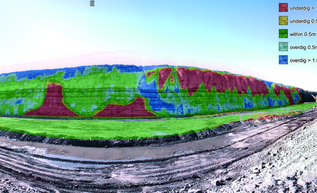
PerfectDig is engineered to run with Maptek’s I-Site 8800, 8810 and 8820 laser scanners, while a worker using a rugged-ized tablet outfitted with the field software can access the data on the run and view enhanced photos and cross sections, distance to design and two-point distance queries among other things.
The enhanced photos consist of the current reality of the mine, overlayed with extra information, creating an augmented reality which shows areas of underdig and overdig as well as other discrepancies.
According to Johnson, the software has been doing well for the company since it was released last year.
“Certainly within Australia, North America and Canada it’s been taken up quite well, and between metal and coal mines we’ve got strong interest across the whole range so we’re quite happy with it,” he said.
“In terms of a new product it’s been taken up a lot faster than we might usually expect but I think it’s a very simple value proposition and people can see the obvious benefits straight away.”
Some of these benefits, according to Maptek, include being able to keep a closer eye on hardcap compliance – making sure that excavation doesn’t go beyond the hardcap threshold, identifying safety issues such as overhanging material near the top of a wall early, and aiding the ongoing improvement of drill and blast operations.
“PerfectDig has the potentital to deliver immediate benefits to operations through cost savings in equipment deployment and efficient removal of overburden,” Maptek said in a release related to the technology.
“Improving the overall conformance to design process also has wider implications for continuous improvement of ore recovery.”